Maui Rainfall Zones Disinformation Is Making the Rounds On Social Media
Don't Fall For It. There Is Likely More Disinfo Than This Going Around.
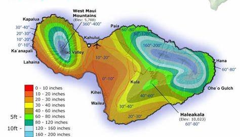
This is a correct Maui rainfall zone map. Like all the Hawaiian Islands the Southwest is generally dry and the Northwest wet. Higher elevations receive anywhere from 5 to 40 feet of rain a year. Lahaina is in the zone receiving about 20 inches a year on average but was in a severe drought heading into this. Look what’s making the rounds on Gab………..
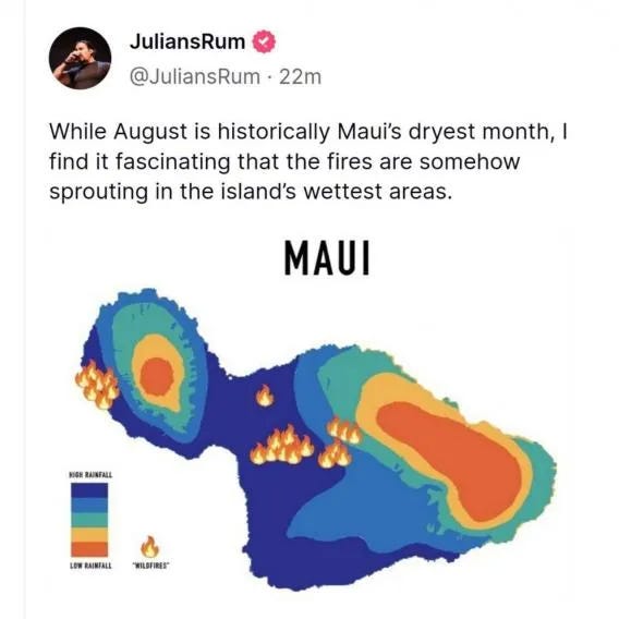
The zones on this map are roughly the same as above but with less detail. Some operative, however, has reversed the Key to make it look like Lahaina is in the highest rainfall zone. Very clever but did not get by me. I was already familiar with rainfall patterns on these islands. Geography has been a passion my entire life! Please pass this on. People need to know to watch out for clever disinfo like this.


Ah, I did NOT know. Interesting.
I wonder IF the underbrush was being attended too or just left as kindling.
So many questions.
Good eye. I can't get over how much it looks like a head!
Leeward side of the islands are DRY.
Windward (North side) of the islands are WET.
Lahaina is DRY, but there's little fuel to get a fire like this going. You would be surprised what can catch fire with a quart of gasoline, a match and no fire truck or water to fight the fire with an 80mph wind. Fires can be put out when they are SMALL and easy to contain. Once they get big, you get out of the way.
More on these weaponized wildfires here: https://decodetheworld.substack.com/p/fire-season-weaponized-wildfires